WHY SHOULD I VISIT NAMIBIA?
Here are our top five reasons why you should visit Namibia:
- Sossusvlei – highest fixed dunes in the world
- Etosha National Park – home to the Big 5 in harsh desert surroundings
- Damaraland and Kaokaland – desert-habituated rhino and elephant
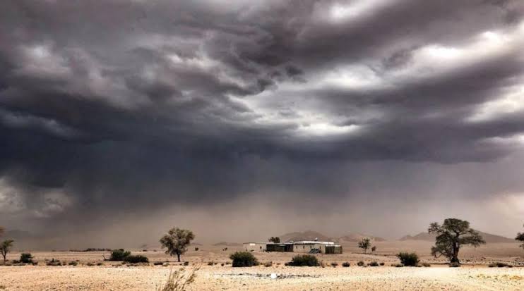
- The Skeleton Coast
- Caprivi Strip – game reserves, Chobe, and the Zambezi River
Namibia is the place to experience the wide, open spaces and unending vistas. It is a common misconception that Namibia is just sandy desert, while Namibia has large savannahs, some high mountains, and the tropical bush of the Caprivi Strip.
When Is the Best Time of The Year to Visit Namibia?

Balloon Safari in the Sossusvlei – Namib Sky
The best time to visit Namibia is during the cooler dry season from May to October. During the summer, November to March, Namibia can get unpleasantly hot. Namibia is a very dry country with over 300 days of sunshine per year. What rain does fall, does so mainly in the summer months, December to March, with rain possible in November and April.
The Caprivi Strip, which is much greener and more tropical, has a similar pattern, but does receive quite a bit more rain in the form of thundershowers. It is good to bear in mind that during the winter months, while the skies are clear and the days sunny, the mornings can be quite cold.
For birders, the best time is November to April when resident species are joined by many migrant species, especially in the Caprivi Strip and Kunene region.
Which places should I include in my visit?
As no trip to Namibia would be complete without a trip to the Sossusvlei area with its high red dunes, when planning a trip to Namibia, start with this area. Etosha is a huge draw card for wildlife lovers, as the game is easy to see, and particularly during the dry months, congregate around the waterholes. Damaraland and Kaokaland are beautiful in their own right and have the added advantage of being the playground for the desert-adapted Rhino and Elephant.
Swakopmund and Walvis Bay are undoubtedly the activity capitals of Namibia and offer, in addition, the added attraction of the cold Atlantic Ocean and its beaches. The Skeleton Coast’s stark beauty and numerous shipwrecks offer another aspect to Namibia, but this area tends to be quite pricey. The Fish River Canyon (third-largest in the world), the Kalahari Desert in the south of Namibia, the Waterberg, the Kunene, and Caprivi Strip are all very different, and are well worth a visit during a longer stay in Namibia.
How long should I visit Namibia for?
- For a shorter stay, we recommend a minimum stay of one week. We suggest a combination of the Sossusvlei, Swakopmund/Walvis Bay, and Damaraland, or Etosha, Damaraland, and Swakopmund/Walvis Bay. This can be either fly-in or self-drive.
- For a slightly longer stay (three or four extra nights), add on Etosha or Sossusvlei.
- For a two-week stay, and on a self-drive itinerary, you may choose to include the Kalahari and Fish River Canyon, or the Kunene and Kaokaland, or even the Caprivi Strip.
As Namibia is such a large country, so if you want to be able to see most of Namibia at leisure, a stay of three weeks or longer is recommended. This can only really be done by driving, as the fly-in options are possible, but very pricey.
What is the weather like in Namibia?
One of the rare rainy days – courtesy of SA People
Namibia has four seasons. Summer is from October to March, winter from June to August, and spring and autumn in between.
The majority of Namibia is hot and dry, and has low humidity, but the Caprivi Strip and Kavango region is tropical, greener, receives much more rain, and is much more humid. The central highlands, due to altitude, are more temperate and experience more rain, but would still be considered hot and dry.
The coastal belt is quite different to the rest of the country and receives even less rain. Temperatures are moderate, as the prevailing south-westerly wind is cooled by the cold Benguela Current. Fog banks blanket this region for over half the year, and can last for most of the morning on occasions.

South & West Namibia Climate Chart

High-lying areas and north Namibia Climate Chart
Do I need a visa to visit Namibia?
Passport holders of 55 countries do not require a visa to enter the country for tourism purposes. These include SADC countries, North America, Brazil, most of Europe, Russia, Australia, Japan, and some of South East Asia. For those nationalities that need visas, a visa for the majority of nationalities can be obtained on arrival in Namibia. Be aware that the process at the ports of entry is currently time-consuming, so it is recommended that you obtain a visa beforehand, if possible.
What are the health requirements for Namibia?
Namibia has a low to moderate risk of malaria in most areas, with the exception of the Omaheke region, north and north-east of the country. Anti-malaria medication is recommended when travelling to these areas, and you should consult your doctor in this regard. To minimise the risk of contracting malaria, wear long trousers and cover your arms in the evening, and apply mosquito repellent.
Yellow fever vaccination is required if you are coming from an endemic country. The following vaccinations are recommended, but not compulsory:
- Hepatitis A and B
- Typhoid
- Tetanus
- Diphtheria
- Rabies
- Cholera
How can I travel around Namibia?
By far the most convenient and cost-effective way to travel around Namibia is by car on a self-drive holiday. Most roads, with the exception of the main roads, are gravel and are usually in a very good condition. Travel, however, is slower, as we do not suggest that you travel faster than the prescribed 80 km per hour. It is possible to be transferred between destinations, but this pushed up the cost. Quite a number of people opt for their own private driver and vehicle throughout their stay, which has the added advantage of both flexibility and local knowledge.
Flying between major destinations by light aircraft, both scheduled and charter, is by far the quickest way to travel and offers a birds-eye view of the country.
The local bus service is not extensive or particularly desirable, but several routes are serviced by luxury bus services, which is definitely an option.
TOP TOURIST ATTRACTIONS
Etosha National Park

Zebra in the Etosha as the rain approaches
Etosha National Park has the largest salt pan in the world, so large that it can be seen from space. The pan fills up with water when it rains and attracts huge flocks of flamingos to its shallow waters. The park has numerous waterholes, including at the main rest camps, which attract animals and provide a never-ending show of the wildlife that make Etosha National Park Namibia’s premier wildlife destination.
The waterholes at the rest camps are flood-lit, so that the nocturnal species are also often seen.
There are about 114 mammal species found in the park. Birding is best in the wetter summer months, and the park has 340 species, one third of which are migratory.
Sossusvlei & Namib Naukluft Park

Sossusvlei at dawn
The Sossusvlei Pan and Deadvlei, the most well-known attractions of the park, are both found on the eastern side of the Namib Naukluft Park. The Namib Naukluft Park is a combination of huge sand dunes and the rugged Namib Naukluft mountains. The Sand Sea, the only coastal desert in the world that is influenced by banks of fog, covers over 3 million hectares, and encompasses dunes of all types, including pediplains, playas, and inselbergs. The Sand Sea extends to the Atlantic coast and has its own unique ecology and wildlife.
The Sossusvlei (dead-end marsh) and adjacent Deadvlei are the end of the road as far as the Tsauchab River is concerned. The river, which only flows in very wet seasons, is widely believed to have reached the Atlantic Ocean until the massive dunes blocked its path. The petrified trees in the Deadvlei are both beautiful and haunting, and stand as a testament to the fact that water was once available for the trees to grow. They are accessible by a good tar road to the 2×4 vehicle parking lot, and it is only a short distance to the 4×4 parking lot from where you have to walk to visit the Deadvlei with the Big Daddy dune towering over it. All along the road you can visit, climb, or have sundowners on stunning dunes, all with their own unique number, like Dune 7 and Dune 45.
The Namib Naukluft Park is the fourth-largest terrestrial conservation in the world, and boasts the world’s highest fixed dunes. The wildlife that inhabit these dunes are unique and well-worth seeking out. Also of interest is the 30 m-deep Sesriem Canyon that was carved out by the Tsauchab River eons ago. One of the most photographed areas in the world, this area is a must see for visitors to Namibia.
NamibRand Nature Reserve

Wolwedans in the NamibRand Reserve
The largest private nature reserve in Africa, the NamibRand Nature Reserve was formed to create an area free of fences that, together with the Namib Naukluft Park, would allow the wildlife of the desert to roam free of restrictions. The reserve is bordered by the Namib Naukluft Park in the west and the Nubib mountains in the east. It is a continuation of the same landscape that you find in the Namib Naukluft Park, and has the same stark beauty and kaleidoscope of colours that attracts photographers to this area.
Fish River Canyon
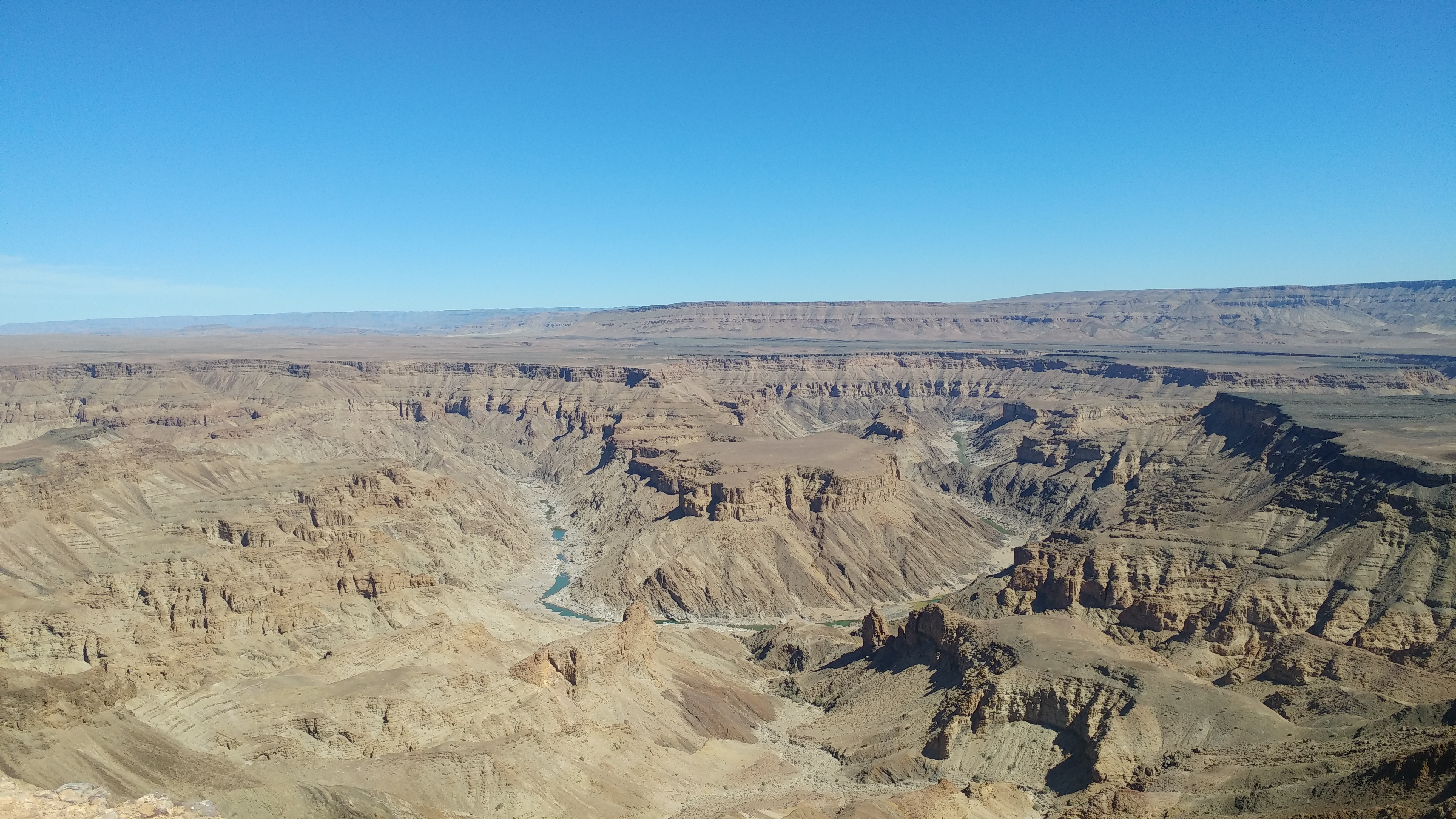
Fish River Canyon – world’s second largest
The world’s second-largest canyon, through which the Fish River flows, offers amazing views, viewpoints, a tough multi-day hike for the adventurous, and hot springs for relaxing in. It is part of the Ai Ais Richtersveld National Park that spans the north-western part of South Africa and southern Namibia.
Swakopmund & Walvis Bay
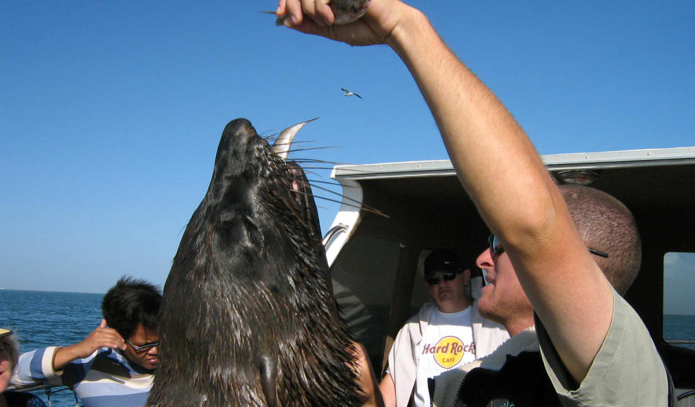
Seal on the boat during a seal cruise
Situated on the central west coast of Namibia, the German influence can be vividly seen in the architecture of the city. With the cold Atlantic as its backdrop and the 200 or more days of morning fog, Swakopmund is both mysterious and quaint.
While Swakopmund has sandy beaches, it is not a beach destination, as the sea is cold and the weather mild and variable. Together with Walvis Bay, 30 km to the south, Swakopmund offers many adventure activities, such as quad biking excursions, paragliding, kayaking, seal and pelican boat tours, dune visits, birding, 4×4 trips, to name only a few. If it is a few days of rest and activity you want during your Namibia trip, Swakopmund is the place for you.
The Kalahari Desert
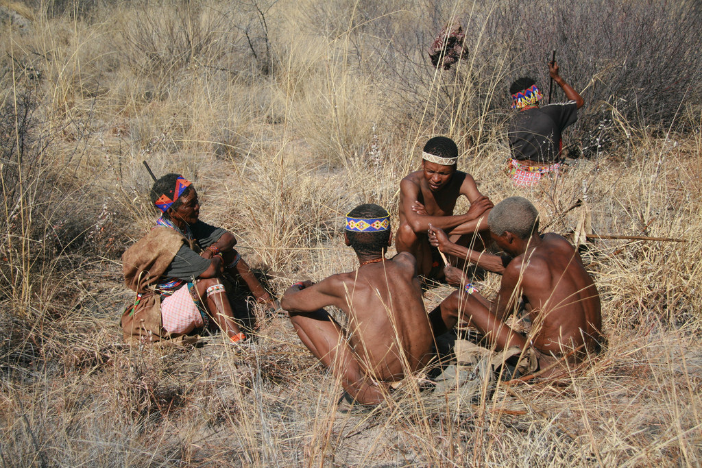
Khoisan family group eeking out a living in the Kalahari
The desert extends through seven countries of Southern Africa, Namibia being one of them. It is better referred to as a vegetated desert, and in this part of Namibia, it is characterised by grasslands interspersed with small red dunes. It is one of the areas in Namibia where you can visit bushmen that live in the same way they have lived for thousands of years.
Damaraland

Wilderness Safaris Damaraland Camp
Damaraland, named after the Damara people that lived here, is one of the most scenically diverse areas of Namibia. It is an assortment of grassy savannah plains, rocky mountains (the highest of which is the famous Brandberg), deep gorges, and barren, sandy wastelands to the west. Besides its natural beauty, the area is famous for the hundreds of Bushman engravings.
It is here that you might find the desert-adapted rhino, elephant, zebra, and lion who have managed to adapt to the harsh, dry environment, and live an existence that defies the odds.
Kaokaland

Desert adapted elephant in Kaokaland
Kaokoland is that part of Namibia that extends from the Hoanib river in the south to the Kunene river in the north, and from the Skeleton Coast in the west to Ovamboland and Etosha in the east. Mostly mountainous with intervening valleys, few areas show off its beauty better than the Marienfluss and Hartmann’s valleys. Another feature is the Kunene river, on which you will find the Ruacana and Epupa Falls. White water rafting, canoeing, and birding are a few of the activities the area offers.
kaland is also home to about 5000 Himba people. The Himba women are easily identified by the red ochre and fat they cover themselves with to protect them against the harsh African sun. They are also well-known for their unique hairstyles and traditional adornments. It is fascinating for tourists to visit traditional Himba people in their villages, but this is becoming less likely as the modern world becomes ever more accessible and most so-called “authentic” Himba tours are just put-on displays for the tourist.
The Caprivi Strip

Kwando Camp in the eastern CapriviThe Caprivi Strip is a narrow strip of land that runs east-west in the far northern part of Namibia. At its tip, it widens out somewhat and ends where Botswana, Namibia, Zambia, and Zimbabwe meet. This is an area that is characterised by some of Africa’s great rivers, including the Okavango, Kwando, Linyanti, Chobe, and the mighty Zambezi.
Quite different to the rest of Namibia, it is tropical and green. A number of national parks and reserves are found in the Caprivi. They are (from west to east): Mahango National Park, Bwabwata National Park, Popa Falls Reserve, Kwando Game Park, Mudumu National Park, and Nkasa Rupara National Park, which is part of the Kavango Zambezi Transnational Conservation Area.
Popa Falls is not really a waterfall as we know it. Being only 2,5 m high, it is essentially a series of rapids. It is geologically significant, as it is the first of five geological faults, and to the south, the Okavango Panhandle feeds the famous Okavango Delta.
Mahango National Park is characterised by a wetland surrounded by Kalahari sandveld. This combination ensures that water birds and dry-country birds can be found within a small area. The reserve also has abundant wildlife, including red lechwe, sable, and sitatunga.
Bwabwata National Park is traversed by the main road linking western Namibia with Botswana, Zambia, and Zimbabwe. The park has not yet been developed, and few tourists use it for anything more than an area to pass through enroute elsewhere.
Mudumu National Park is flanked by the Kwando River on the west, which eventually empties into the Linyanti River. Buffalo, large herds of Elephant, the rare sable and roan antelope, the red lechwe, and sitatunga are amongst the variety of animals you may see when visiting the park.
Nkasa Rupara National Park is reminiscent of the Okavango Delta. The Kwando and Linyanti Rivers provide permanent water, but flood the adjacent grasslands during the wet season, leaving only wooded islands above the water level. It is an important conservation area, as it is part of the migratory area for large herds of elephant and buffalo. It does, however, have resident buffalo herds, several prides of lion, and a range of antelope species.
Waterberg Plateau National Park

Waterberg Plateau
The park is unusual, as it rises above the surrounding areas, up to 420 m in places. Most of the park is inaccessible, making it the ideal area to relocate endangered species for their protection.
With over 200 bird species, it is one of the best birding locations in Namibia
Namibia is an ancient land of enormous contrasts. Contact Q2 Travel to plan you Namibian experience.
GENERAL INFO & HISTORY
Few countries are more photographed than Namibia. As a country of wide-open spaces, relatively small population, many natural wonders from canyons, deserts, and highlands to the tropical Caprivi, desert-adapted wildlife, quaint cities, ancient cultures, and over 300 days of sunshine, Namibia is uniquely diverse.
Brief History
The earliest people lived in the Huns Mountains in Namibia some 25 000 BC. It is thought that the San and Damara people were the first inhabitants of Namibia, and they were followed by the Herero people that moved down from the East Africa lake region in the 17th century and the Ovambo who lived in north/north-eastern Namibia. The Himba people are a remnant of the Herero people that stayed in Kaokaland when the rest of the tribe moved south into Damaraland.
In the 19th century, the white farmers (Boers) moved into the north-western part of South Africa, displacing the Khoisan people who crossed the Orange River into southern Namibia. These bushmen adopted the customs of the Boers and developed a language very similar to Afrikaans. They were known as the Oorlam people. Clashes between the Oorlam people and Nama people who lived in southern Namibia resulted in the Oorlam people taking the best grazing land. The Herero, who were pushing south, caused the Nama people to enter into an agreement with the Oorlam people who would protect them from the Herero people in exchange for receiving tribute from and exercising control over the Nama. The Oorlam people eventually settled in what is today known as Windhoek, which was the southernmost extent of the Herero lands.
The Basters, offspring of Boer men and African women, were pushed north by the Afrikaners, crossed the Orange River, and founded Rehoboth.
Over the coming decades, the Afrikaner, Herero, Damara, and Oorlam people fought for control of the prime grazing of Damaraland, resulting in many Damara people being killed. Ultimately, the Afrikaner prevailed, and the Herero paid tribute to them in the form of cattle.
As far as European involvement in Namibia, it was the Portuguese that first landed in Namibia in the 15th century, but were put off by Namib Desert, and so, did not move inland. The Dutch authorities in the Cape took control of the only deep water harbour along this section of the coast, namely Walvis Bay, in 1793, and subsequently ceded this control to the British when the British assumed control of the Cape Colony in 1797.
German missionaries started to work in Namibia in the 1840s. In 1884, Otto von Bismarck laid claim to Namibia believing that the British were about to do likewise. He declared it a colony and named it German South West Africa. Following an agreement between the Portuguese and Germans in 1886, the border between Angola and Namibia was decided, and as a result of the Heligoland-Zanzibar Treaty, the British gave up the Caprivi Strip to the Germans in exchange for Zanzibar.
The so-called “Hottentot uprising” was the resistance to German occupation by the Namaqua people, led by Hendrik Witbooi. The resulting treaty would allow the Namaqua to keep their weapons if Hendrik Witbooi brought the uprising to an end. As the only German Colony suitable for white people in Africa, many Germans settled in Namibia over the next few years, and more were attracted by the discovery of diamonds in 1908.
In 1904, the Herero attacked and killed about 150 German farmers, bringing them into conflict with the Germans. The Namaqua people, under Hendrik Witbooi, soon joined the Herero. The Germans responded by sending 14000 troops. The Herero were given an ultimatum to leave the country or to face death. The Herero fled into the Omaheke and Kalahari regions where many died of thirst. The Germans poisoned many wells in the Namib Desert, and were issued a shoot-to-kill order for any adult Herero male who approached water sources that the Germans had placed under guard. During this period, over 50% of both the Namaqua and Herero people were killed.
At the beginning of World War I in 1914, the British captured Luderitz, which cut off German supplies. In 1915, 40 000 South African troops entered South West Africa, driving the Germans to surrender in July 1915. Half of the country was given to 3000 white settlers who received big subsidies from the administration.
Although disputed, South Africa continued to rule South West Africa through the office of an Administrator until 1948, during which time only white settlers were allowed to vote. In 1946, South Africa refused to allow its mandate to be replaced by the United Nations Trusteeship agreement, and continued to treat South West Africa as one of its provinces. During the ensuing period, the South African administration tried to disguise the implementation of racial segregation and separate development as progressive reforms via the Odendaal Commission. This move united the black opposition to the ruling power with SWANU (South West African National Union) being founded in 1962, and in 1966 SWAPO (South West Africa People’s Organisation) and PLAN (People’s Liberation Army of Namibia), both black resistance movements, starting guerrilla attacks on the South African administration.
A whole lot of politics ensued, both locally and internationally, resulting in the United Nations revoking South Africa’s mandate to rule South West Africa and eventually trying to take over the administration in 1967, unsuccessfully. South Africa retaliated and started to exercise direct rule in 1969, illegally. South Africa’s plan was to divide the country into independent ethnic states for which they passed the Development of Self-Government for Native Nations act. The UN then retaliated by endorsing SWAPO, who was backed by the communists, as the only legitimate representative of the people of South West Africa.
Due to the continuing guerrilla attacks, South Africa moved a large military and police force into Namibia to protect locals that had not joined SWAPO and the white farmers. Changing tack, due to international pressure, South Africa then tried to gain favour with the international community by proposing the establishment of a federation of self-governed states. The overriding reason for this change of tack was to prevent SWAPO from coming to power and retaining control over the mineral wealth of the country. This proposal was rejected by the UN and SWAPO.
SWAPO started to increase its guerrilla attacks, which led South Africa to retaliate by moving many more troops into South West Africa, and eventually southern Angola, where SWAPO has set up bases with support from the communist-backed MPLA.
Political manoeuvring would continue until 1988, when UN resolution 435 resulted in an agreement between South Africa, SWAPO, the UN, and the international community, led by the USA. An 11-month transition period followed, elections were held in November 1989, and finally, South West Africa gained independence on 21 March 1990, and changed its name officially to Namibia. Walvis Bay, however, remained under South African control until 1994.
Since their independence, multi-party democracy has been the order of the day, but SWAPO has won every election since then.
Economy
Mining constitutes the backbone of the economy along with agriculture. Namibia is rich in mineral wealth, including silver, lead, uranium, zinc, tin, and diamonds. The agricultural sector employs more than half of the population. Tourism is growing rapidly and becoming a major contributor to the GDP.
People & Culture
Amongst the many local cultures, two stand out, namely the Khoisan and Himba. With these cultures dating back hundreds of years and remaining virtually unchanged, they give the tourist a glimpse into the past. These cultures highlight how humans have managed to carve out an existence in the harshest of environments and use the land to its maximum without destroying it, in stark contrast to the majority of the world.
Although these cultures have, for centuries, withstood the pressure of change. They are disappearing quickly, and only small pockets remain that can truly claim to be authentic.
Money
The local unit of currency is the Namibian Dollar, which retains its 1:1 relationship with the South Africa rand.
Namibia is a truly a place like no other, and one we definitely recommend that you add to your travelling bucket list. Contact us if you are ready for an adventure in Namibia.
Latest Articles
- Seychelles eTravel PromoOctober 27, 2025 - 8:49 am
- Reunion eTravel PromoOctober 27, 2025 - 8:41 am
- New specials coming soonJune 3, 2025 - 1:34 pm
- African Safari Tours – Part 4 – Big 3 African Transfrontier ParksDecember 9, 2019 - 7:57 am
 African Safari Tours – Part 3 – Zimbabwe’s trio of safari must dos.November 18, 2019 - 7:07 am

